Ponchartrain
Mariners' Museum, Uncurated Search Results
Type: Coast Guard Cutter
Year:
Builder:
Location:
These records are found in the online catalog of The Mariners’ Museum and Park in Newport News, Virginia. Uncurated search results are presented to give researchers and interested readers an idea of whether the museum’s archives contain information about this vessel and whether it may be worthwhile to visit the museum’s catalog search page for further investigation. Uncurated results may be inaccurate or incomplete.
Search mode: Exact Name. Search phrase(s): "Ponchartrain". Results returned: 3. Results displayed in this table: 3.
Use these buttons to send uncurated search results to your own app or text document for further research. First, check the box for any row, or click "Select All" then uncheck any rows. Then click "Show Selections". You can then copy your selections from the text box and past them into your app.
| Fetch? | Row ID | Media | Date | Vessel | Place | Related Places | Inscription/Marks | Subject | Notes | Archive Number |
|---|---|---|---|---|---|---|---|---|---|---|
| 1 | No image URL. | Contains photographs from the New Canal Lighthouse erected on the New Basin Canal from Lake Ponchartrain. | MS0340/-01.19 | |||||||
| 2 | 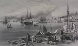 | SHORT DESCRIPTION: The print shows New Orleans with many ships on the waters of Lake Pontchartrain. In the foreground there is a wooden dock or pier that has many barrels on it, as well as bunches of bananas still on the stalks. There is a makeshift awning or tent with a group of men under it and around a table, and three other people sit on bales of cotton on the right side. The steamships on the water trails of steam coming from their funnels. The city is on the right side of the background. NOTES: From “Picturesque America, or The Land We Live In” volume 1, published in New York by D. Appleton and Co. publishers, 1872. The print is before page 265. The date on the print is 1873, but the book was published the year before. NOTES: The domed building in the city skyline is Immaculate Conception, a Catholic church built in 1857. Due to foundation issues the church was rebuilt between 1928 and 1930 with the same architectural design as the first building. One of the steamboats has the name Natches (most likely a misspelling) on the wheelhouse. From the date of this print this is most likely the seventh of nine steamboats named Natchez, this is the one that raced the General Lee in 1870. This Natchez was built in Cincinnati in 1869 for Captain Thomas P. Leathers, then dismantled in 1879. | CL16402 | |||||||
| 3 |  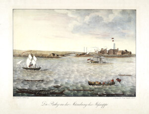 | SHORT DESCRIPTION: Hand colored engraving titled "Die Balize an der Mündung des Mississippi." Print depicts the La Balize settlement near the mouth of the Mississippi River. The village is visible with its large skeleton tower flying two flags. To the left of the village is a ship with masts but no yards, a small boat under sail, and a beached hull. Another small boat sits among the marsh near two small buildings. There is a ship under sail at the left, another sailing ship under tow by a sidewheel steamboat with two stacks in front of the village, there are two alligators, one sunning itself on a log while the other shows only the head and neck in the foreground at the bottom left. In the foreground at the right is a small boat filled with cargo being rowed by five or six men and steered by another man standing at the stern. NOTES: Friedrich Paul Wilhelm, the Fifth Duke of Württemberg, was one of the most important explorers of the Upper Mississippi and Missouri Rivers. Friedrich Paul Wilhelm made his first expedition to the United States in years 1822 to 1824. His diary described the places he visited in great scientific and ethnological detail. Wilhelm arrived in New Orleans in December 1822. His party took a riverboat up the Mississippi to St. Louis, where the Duke met with the Superintendent of Indian Affairs, William Clark, who granted him a passport into the interior country. This engraving, "Die Balize an der Mündung des Mississippi," was made from a watercolor created by Wilhelm on the expedition, possibly for use as an illustration in the published account of his expedition (Reise nach dem nördlichen Amerika in den Jahren 1822 bis 1824--although the two copies reviewed so far show no illustrations other than a map of Louisiana). The print illustrates the town of La Balize at the mouth of the Mississippi River. In describing La Balize, Wilhelm noted: "The few wooden houses which make up the place stand on piles in the midst of the water and slime, between high reeds; and one house can only be reached from another along plank footpaths." Regarding the alligator in the foreground, Wilhelm observed that in the warm season "exceedingly large numbers" of them inhabit the banks. "It seems a mystery how these obviously voracious creatures are able to find prey enough to still their hunger." On his second expedition to America, Wilhelm discovered the headwaters of the Missouri (1829). NOTES: La Balize, Louisiana, was the first French fort and settlement near the mouth of the Mississippi River, in what later became Plaquemines Parish. Inhabited by 1699, La Balize was one of the oldest French settlements in modern Louisiana. Historically and economically important for controlling or overseeing passage along the river, it was inhabited chiefly by fishermen, river pilots, and their families. The pilots were critical to helping ships navigate to and from the port of New Orleans through the shifting passages, currents and sandbars of the river's delta. The village was vulnerable to seasonal hurricanes and was regularly damaged or destroyed by hurricanes. It was washed away in a hurricane of 1740 and rebuilt on the newly emerged island of San Carlos. That village in turn was damaged severely several times and finally destroyed. By 1853 the village of La Balize, also called Pilotsville, was about five miles to the northwest in the Southwest Pass, on the west bank of the Mississippi. That village was taken down by wind and a storm surge of the September 14–15 hurricane of 1860 prompting the permanent abandonment of La Balize. A new pilots' settlement was constructed about five miles upriver on the east bank of the Mississippi, just above the Head of the Passes. The new village was named Pilottown. After Hurricane Katrina, the town was abandoned and currently has no permanent residents. The first steamboats appeared on the Mississippi in 1811 and by the time Wilhelm visited in 1822 there were so many that it is impossible to determine the vessel towing the sailing ship. It does have some distinctive features: propelled by sidewheels, two stacks. ADDITIONAL INFORMATION: *See 'Erste Reise nach dem nördlichen Amerika in den Jahren 1822 bis 1824' by Paul Friedrich Wilhelm, Duke of Württemberg, 1835 *See "Lake Ponchartrain," W.A. Roberts, p. 272. See "The Port of New Orleans," Harold Sinclair, p. 267. See Lippincott's "Gazetteer". *See Capt. Hall's "Travels in America," p. 334-340. *See Reps, John William. Views and Viewmakers of Urban America: lithographs of towns and cities in the United States and Canada, notes on the artists and publishers, and a union catalog of their work: 1825-1925. Columbia: University of Missouri Press, 1984, P. 313, catalog 1172. *See Stokes, I.N. Phelps and Daniel C. Haskell. American Historical Prints: early views of American Cities, etc. from the Phelps Stokes and other collections. New York: New York Public Library, 1933, p. 65. *See Deak, Gloria Gilda. Picturing America, 1497-1899. Prints, Maps and Drawings Bearing on The New World Discoveries and on the Development of the Territory that is Now the United States. From the I.N. Phelps Stokes Collection and Other Collections In the Miriam and Ira D. Wallach Division of Art, Prints, and Other Photographs of the New York Public Library. Volume I & II. Princeton, N.J.: Princeton University Press, 1988, p. 228, catalog 334. | CL20424 |
Created 2026 by Don Barker, CBMM volunteer, for the Chesapeake Shipbuilding Project. shipbuilding@sailingworkboats.es